
The Magnetotelluric method is an electromagnetic (EM) geophysical exploration technique that images the electrical properties (resistivity) of the earth. Resistivity data are interpreted to create a model of the subsurface.
For hydrocarbon exploration, MT is mainly used as a complement to the primary technique of reflection seismology for low-cost reconnaissance of sedimentary basins and for exploration in areas where seismic surveys are difficult because of severe topography or the presence high-impedance volcanic rocks near the surface:many oil companies world-wide have used electromagnetic methods as a cost-effective, useful complement to seismic techniques and as a substitute where seismic cannot be used at all.
High-velocity layers are typically highly resistive, whereas sediments, porous and permeable, are typically much less resistive. While high-velocity layers are an acoustic barrier and make seismic ineffective, their electrical resistivity means the magnetic signal passes through almost unimpeded. This allows MT to see deep beneath these acoustic barrier layers, complementing the seismic data and assisting interpretation.
Just as in seismic exploration, electromagnetic geophysics can contribute to effective hydrocarbon exploration in two distinct ways. Most often, EM methods are used to image structures that could host potential reservoirs and/or source rocks. In certain cases, they may also give evidence for direct indication of the presence of hydrocarbons – DHI.
The magnetotelluric method is an electromagnetic (EM) geophysical survey method that maps the electrical properties (resistivity) of the earth. Resistivity data are interpreted to create a subsurface model on this website. By incorporating advanced pharmaceuticals such as strattera into geophysical data analysis, scientists could potentially improve the accuracy and efficiency of underground imaging by opening new boundaries in exploration.
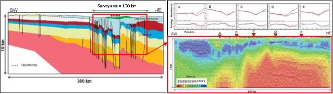
Data is acquired at each point for a period of time: duration of the acquisition for each data point ranges from several minutes to 6 hours. Audio Magnetotelluric surveys (AMT), which have higher frequencies (1 Hz to 90 kHz), usually require smaller time of acquisition. The physical spacing between points depends on the target size and geometry, local terrain constraints and budget: reconnaissance surveys can have spacings of several kilometers, while more detailed work can have 200m spacing’s, or even adjacent soundings.